 Cape
Hatteras
Cape
Hatteras
Beach Wrecks
|
Beach Wrecks |
|
|
General Information:
I get many inquiries about wreck sites that can be dived from the beach and this is an often asked question on the internet forums about NC diving as well. I looked through my old log book for information - much of which is now 20+years old - and developed this page to help divers wanting to try some beach diving. Most of the sites I know about are off the beaches in what is the Northern Outer Banks - Kitty Hawk and Kill Devil Hills areas. Though ships came ashore the entire length of the OBX, we do not have any dive sites that I know of South of Rodanthe on Hatteras Island other than the Frisco pier site and it has not been dived in many years. There my be other wreck sites, but the ones on this page are what I know about. All of the information listed here is approximate and may be somewhat dated, so use it accordingly and at your own risk. If you have current information about the condition of these sites, comments or better information, please let me know and I will update. There is an excellent book about shipwrecks on the beach "Shipwrecks of the Outer Banks" by Kevin P. Duffus (ISBN 1-888285-22-2) that has a great deal of other information and the locations of many other shipwrecks viewable on the beach. Diving Conditions: The diving conditions on any of the sites will vary widely depending upon the sea state of the Ocean and just how rough it has been lately. In general I found that a breeze blowing off the beach and a High tide to have provided the best conditions, but that may also vary greatly. Also, like any shipwreck, the wreck conditions will vary greatly from year to year with many sites disappearing completely beneath the sand one year and then being even more exposed the next. Visibility can change drastically as well from unbelievable to zero and back again, this mainly is controlled by the wave action - less is always better. Use caution and good judgment when attempting a dive on a beach wreck site - if the sea is not cooperating fully, try another day. The Beach Wrecks: For some sense of order in presentation, I will go from North to South. Metropolis: Corolla area. This is a small freighter that was just 879 tons and about 120 feet long. This vessel was formally a Federal Gunboat named the Stars and Stripes. She was carrying 500 tons of iron rails and 200 tons of stone when she went down in 1878 with the loss of 91 lives. It is located about three miles South of Currituck Beach light in Corolla and is about 100yards off the beach in 15 to 20 feet of water. I do not remember the exact location off the beach but this site was locally known as the "Horsehead Wreck" back when I dived it. Winks Wreck: MP2 area. This wreck sits in 15 to 20 feet of water about 100yrds or so off the beach between MP2 and MP3. It was called the Winks wreck as it is near the Winks store located at Eckner St and the beach road. Local Diver Marc Corbett has been diving this site for the past several seasons exploring the wreckage for clues as to the identity of the vessel. His persistence diving this site has revealed information to him as to the identity of this wreck. He now strongly believes that the Wink's wreck site is actually the British Steamer Mountaineer. This information and photographs of this wreck are fully discussed on the Mountaineer web page. Marc has found that the site is not real big so it is somewhat hard to locate. On every trip he found that there was a good deal more current, and less visibility on this site than on a lot of other dive sites in the area. Marc recommends hitting it around high tide to minimize the current and visibility problems. To locate the Mountaineer / Wink's wreck go to
Luke Street in Kitty Hawk. There is a house that sits on the beach
just to the South, it has that brownish green vinyl siding. As you
get in the water you need to look for the house BEHIND that house, and
just to the South. If you line up on the covered porch pilings of
that house (the one behind the house on the beach) and stay on them as
you go out you should find it. It isn't all that far out, maybe
100 yards. You should definitely see it from the surface on a
clear day as the top of the wreck is only about 5 feet or so below the
surface. Old Tug Wreck: MP5 area. This wreck is located near the Avalon pier area, about 300 yards South of the pier not far from the Tanarama motel. There was a small white house just south of the motel that was the landmark and the wreck was fairly close to the beach about 2/3rds the way down the pier or out about 75 yards or so. When I dived it is was fairly covered up with sand, but clearly a wreck site in 20 to 25 ft of water. Best guess is that this site is covered now as the depth off the end of the Avalon pier is reported to be 15 feet according to the pier's web site. Triangle Wrecks: MP7, KDH area. The triangle wrecks are the site of the Carl Gerhard and the Kyzickes. They both had the misfortune to come ashore in the same location, but several years apart. The Kyzickes, a tanker, wrecked first in December of 1927 and was on the beach when the Carl Gerhard, a freighter carrying plasterboard, came ashore during a storm in 1929 and cut the Kyzickes in two.
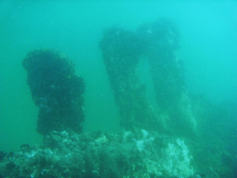
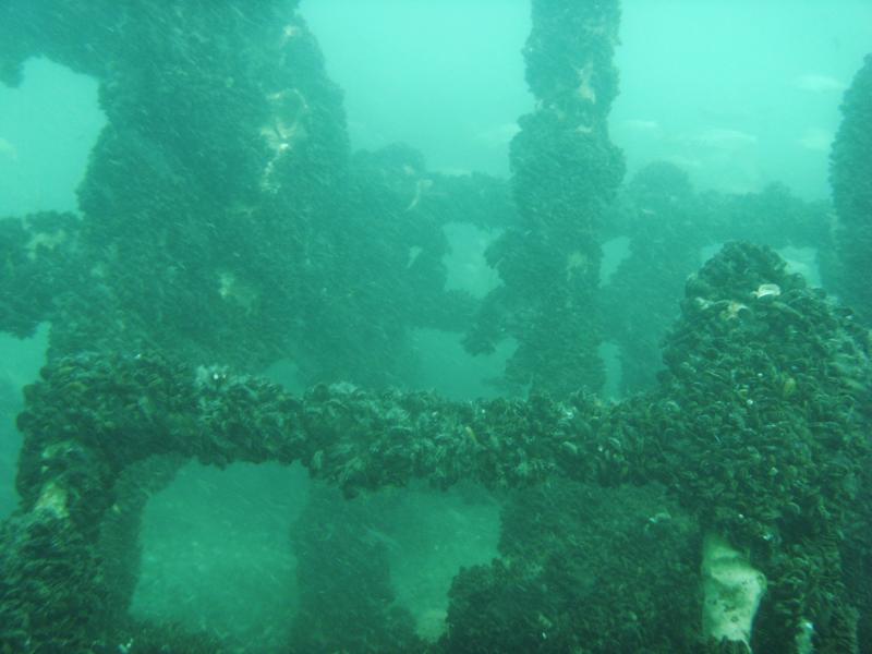
Huron: MP11/12 Nags Head area. Close to the Bladen Street beach access, the Huron is probably one of the better beach dives that you can do as it is well documented and is usually buoyed, making it easy to find. There is detailed information about the Huron, including a site map, at the NC State Archeological web page about the wreck. There is a great deal of information about the Huron wreck in Gary Gentile's Shipwrecks of North Carolina book.
Lois Joyce: Oregon Inlet area. The Lois Joyce, was very typical example of a Wanchese style trawler which didn't quite make it home to Wanchese during a storm in 1982. The wreck was originally much closer to the beach than where she is today, due to the changing shore line. The wreck is laying on it side in 15 to 20 feet of water with the highest relief coming up to within 5 feet of the surface. The outriggers of the wreck used to stand clear of the surface at low tide and the wreck was buoyed at both ends earlier in the 2009 season. To access the site you have to drive on the beach unless you take a boat. It is on the North side of the inlet about 200 yards offshore. The proximity to the Oregon Inlet and the fact that it is now farther offshore makes the site subject to strong tidal currents coming and going from the inlet so it is best to dive this site on a high tide when the water would be slack. It would be best to use surface support such as a kayak at a minimum to do this site. The information on the Lois Joyce was provide by local diver Marc Corbett who has dived it in the past with his last attempt in 2009 thwarted by strong tidal currents.
This site is influenced by the tides coming out of Oregon Inlet and it may be best on the high tide, but sea conditions will probably have the greatest influence on visibility. Water around the wreck is deep enough for small boats to fish this spot so a dive flag would be a good idea. LST-471: Rodanthe area,
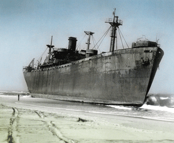
The LST-471 served in the Pacific during WWII and participated in
several of the major battles. After the war she was sold off for
scrap and was being towed to the scrap yard along with another LST, the LST-292.
A storm blew up and the two ships ended up coming ashore on the Outer
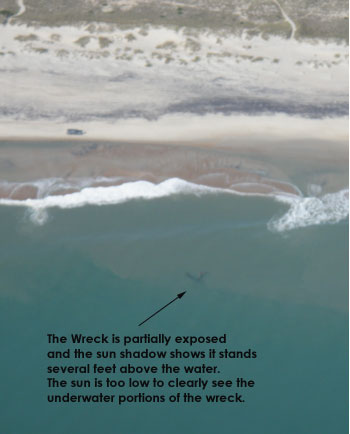
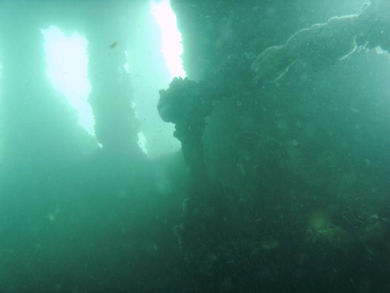
Banks and could not be recovered. LST-471 is The exact location of the LST-292, which is shown in the photo to the right, is being worked on and will be definitely located in the near future. These two sites along with another wreck are depicted on NOAA Navigational chart 11555 from the 1970's through the current chart.
SS Richmond: (Previously
thought to be Pocahontas):
Salvo area - The shipwreck that was formerly thought to be the
Pocahontas is at the end of Sand Street in Salvo.
This wreck is listed in Gary Gentile's book and most other
publications under the Pocahontas name. However, this wreck site
has now been positively identified as the SS Richmond.
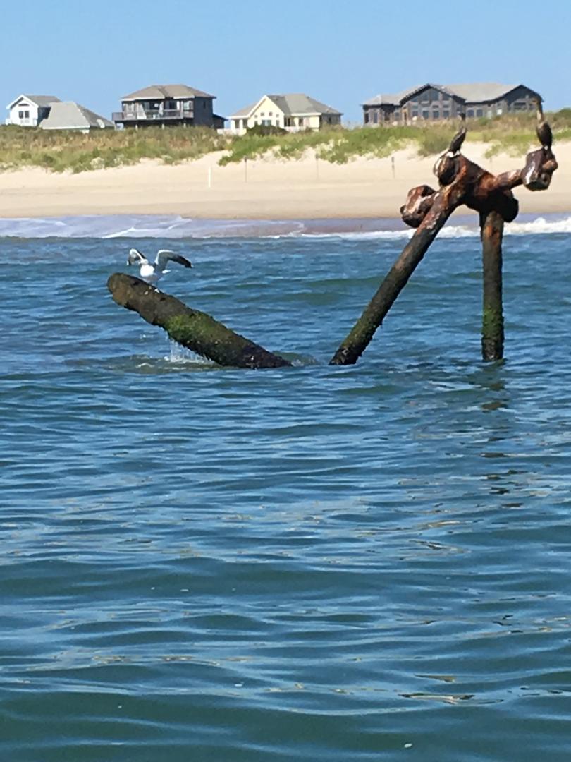
All that remains of this large vessel are the massive steam engine
parts, the shaft and one of the hubs of the paddle wheel. The very
top of the engine and one end of the paddle wheel shaft sticks quite a
ways up out of the water making the site fairly easy to locate the wreck
which is in 10 to 15 feet of water about 75 yards out. The other
end of the exposed shaft is still attached to the other paddle wheel
assembly.
The SS Richmond was formerly the blockade runner Blenheim, built in 1848
by the firm of Tod
and MacGregor, in Glasgow, Scotland. Blenheim served on the route
from Belfast to Liverpool until 1863 when she was sold to new owners.
The new owners acquired her for the dangerous but very profitable
running of the Union blockade and she made 4 trips between Nassau,
Bahamas, and Wilmington NC. On the night of January 24, 1865, on her
fifth run of the blockade, the Blenheim steamed into the New Inlet near
Fort Fisher. When dawn broke on
the 25th, the crew of the Blenheim discovered they were surrounded by
warships of the U S Navy. Fort
Fisher had fallen to the Union days earlier, and US forces had continued
to display night time signals from the top of the mound at Fort Fisher.
The ruse worked, and the
Blenheim was the final blockade runner captured in the Wilmington area. Blenheim was condemned as a prize of war, and purchased at auction by Jacob Brandt, of Baltimore MD, and he renamed the steamer SS Richmond. One year and a day after her capture, the ship was on the way from Savannah, GA to Baltimore, MD when she ran aground at Salvo, supposedly due to a faulty compass. Hatteras Island locals have often called this wreck site the Richmond. They were in fact correct; the presence of what is called a "steeple" engine on the site is the proof. The triangle shaped crosshead, which gives the steeple engine its name, protrudes from the water. The steeple engine was a uniquely British design, and the Richmond, formerly the British blockade runner Blenheim, was built with a steeple engine. Furthermore, the Richmond was the only vessel with a steeple engine to run aground anywhere in Northern North Carolina. It is a really easy dive as long as the water is calm, and scuba is not really a requirement as it is really easy to just free dive this site. The best way to get there is to drive out on the beach at ramp 23 just past Salvo and drive North. In the summer you have to walk a little ways up the beach because the Park Service closes the beach to driving a couple hundred yards South of where the wreck is. In the off season you can drive right up to it. Local diver Marc Corbett provided the information on the Pocahontas wreck site and has dived it recently.
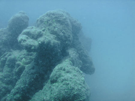
Strathairly: Rodanthe area, The Stathairly was an English freighter that stranded on the beach in 1891. It is located very near the fishing pier and just South of the LST wreck. It is much farther off the beach, and may be too far to swim unless you are in very good condition and the Ocean very calm - a small boat would be a good choice for this site. To locate the wreck use the South end of the Hatteras Island Motel and look for the wreck out about twice the distance of the pier. The wreck is fairly intact and runs roughly parallel to shore with the boilers that rise to near the surface and provide the greatest relief. The overall water depth is 20 to 30 feet. Frisco Pier Wreck: An unidentified wreck is located just to the north of the end of the fishing pier in Frisco, and about 300 yards off the beach. This is generally too far a distance to swim and will require surface support. The approximate location of the site of the wreck is charted on the NOAA Navigation chart 11555 but it is difficult to find without a sounder unless there is extremely clear water conditions then it can be located by sight when over the wreck. Depth is reported to be 16 to 30 feet.
|
All Information, Content and Photos contained on the DiveHatteras web site is property of and copyright by DiveHatteras,
Dave and Ann Sommers unless otherwise noted and my not be used without permission.
Send mail to webmaster@divehatteras.com
with questions or comments about this web site.
Copyright © 2003 Last modified:
01/25/2023

 across from the Pea
Island visitors center. Park either at the center or the lot just
to the north and climb the dunes. You will see the wreck sitting
proud of the water. The wreck is about 100yards out and
perpendicular to the beach with the bow to the the shore. it sits
in 15 to 20 feet of water and is easily snorkeled.
across from the Pea
Island visitors center. Park either at the center or the lot just
to the north and climb the dunes. You will see the wreck sitting
proud of the water. The wreck is about 100yards out and
perpendicular to the beach with the bow to the the shore. it sits
in 15 to 20 feet of water and is easily snorkeled.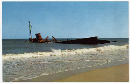 located in Rodanthe, just North of the fishing pier by
about 300 yards and is close to North Holiday Blvd. The wreck used to be fairly intact with a great deal of fish around the
site due to lots of swim through holes for them. The water vis on
this site is usually somewhat better than those to the north as it is
closer to the Hatteras end and gets more of the blue water influence -
but don't count on this every dive. Recent information about
locating the site is to go straight out from Holiday Blvd and just the
slightest bit North so that you line up between the
located in Rodanthe, just North of the fishing pier by
about 300 yards and is close to North Holiday Blvd. The wreck used to be fairly intact with a great deal of fish around the
site due to lots of swim through holes for them. The water vis on
this site is usually somewhat better than those to the north as it is
closer to the Hatteras end and gets more of the blue water influence -
but don't count on this every dive. Recent information about
locating the site is to go straight out from Holiday Blvd and just the
slightest bit North so that you line up between the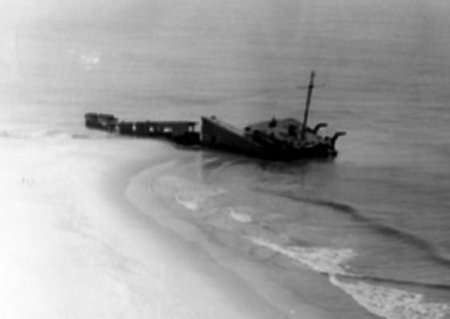 blue and pink
houses. The photos show the wrecks on the beach in the surf, but
beach erosion has changed this and they now lay about
250 yards off the beach. The wreck will be out from the beach farther than the end
of the pier and approximately 250 yards or so off the beach. It is
a long swim, so some surface support device (dive kayak, dingy, etc..)
is very appropriate.
blue and pink
houses. The photos show the wrecks on the beach in the surf, but
beach erosion has changed this and they now lay about
250 yards off the beach. The wreck will be out from the beach farther than the end
of the pier and approximately 250 yards or so off the beach. It is
a long swim, so some surface support device (dive kayak, dingy, etc..)
is very appropriate.